


Home  GIS Layers Fire Data - Fire Scar Maps
| Fire Data - Fire Scar Maps |
 |
 |
 |
| GIS Layers, Resources, Fire | |||||||||||||||||||||
| Monday, 18 January 2010 12:42 | |||||||||||||||||||||
|
Description
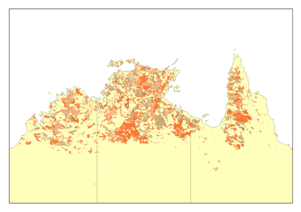
Fire Scar data is derived from a TIF image obtained from MODIS 250m and NOAAH- AVHRR satellite imagery, and is updated every week in the fire season. This layer displays recently burnt country as sensed by satellites.
For more information and details of the process for mapping fire, reliability, and other related information can be obtained from:
General enquiries:
This e-mail address is being protected from spambots. You need JavaScript enabled to view it
Fire scar info and queries:
This e-mail address is being protected from spambots. You need JavaScript enabled to view it
Technical support:
This e-mail address is being protected from spambots. You need JavaScript enabled to view it
|
|||||||||||||||||||||
| Last Updated on Wednesday, 17 November 2010 09:27 | |||||||||||||||||||||

About Us
Funding
Resources
Noticeboard

