


| Fire Data - Australia Fire Frequency Map 1997 - 2008 |
 |
 |
 |
| GIS Layers, Resources, Fire | |||||||||||||||||||||
| Monday, 18 January 2010 09:06 | |||||||||||||||||||||
|
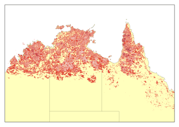
Description
Australia Fire Frequency is derived from a TIF image obtained from NOAA-AVHRR and Modis. This layer displays the number of years an area has been burnt during the period. This layer covers Australia between the periods of 1997-2008.
For more information and details of the process for mapping fire, reliability, and other related information can be obtained from:
General enquiries:
This e-mail address is being protected from spambots. You need JavaScript enabled to view it
Fire scar info and queries:
This e-mail address is being protected from spambots. You need JavaScript enabled to view it
Technical support:
This e-mail address is being protected from spambots. You need JavaScript enabled to view it
|
|||||||||||||||||||||
| Last Updated on Wednesday, 17 November 2010 09:27 | |||||||||||||||||||||

About Us
Funding
Resources
Noticeboard

